On February 14, 2025, Tropical Cyclone Zelia made a significant impact in northwestern Australia, packing destructive winds equivalent to a Category 4 hurricane. With a trajectory that places it near critical ports and mining regions, local authorities have enacted safety protocols for residents.
Tropical Cyclone Zelia Strikes Northwestern Australia with Fierce Winds and Heavy Rain

Tropical Cyclone Zelia Strikes Northwestern Australia with Fierce Winds and Heavy Rain
Tropical Cyclone Zelia has made landfall in Australia, prompting emergency measures as residents are urged to seek shelter amid high winds and flooding risks.
The article text:
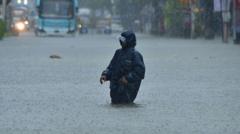
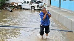
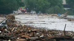
Tropical Cyclone Zelia made landfall on Friday afternoon, February 14, 2025, in northwestern Australia, unleashing intense rain and devastating winds upon a sparsely populated region known for its strategic economic resources, including key ports and major iron ore mines. Residents have been instructed to remain indoors as the storm approaches.
According to Australian meteorologists, the cyclone struck near Port Hedland at approximately 12:30 p.m. local time, just 34 miles northeast of the town, which has a population of around 15,000 in the remote Pilbara region. The storm’s winds, reaching speeds of 132 miles per hour, align with those of a Category 4 hurricane as classified by the U.S. Navy’s Joint Typhoon Warning Center.
A comprehensive tropical cyclone warning was issued from Wallal Downs to Roebourne, about 150 miles from Port Hedland, forecasting extreme rainfall, potential flash flooding, and wind gusts reaching up to 100 miles per hour. Meteorologist Miriam Bradbury from Australia’s Bureau of Meteorology indicated that more damaging winds, potentially as high as 180 miles per hour, were anticipated closer to the storm’s eye, capable of causing significant destruction to trees and infrastructure.
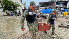
The Australian authorities responded by ordering residents in Port Hedland and surrounding regions to take refuge, advising caution around windows and doors. To mitigate risks, schools and roadways in areas susceptible to flooding have been closed.
Despite concerns, the Bureau of Meteorology has noted that Port Hedland is expected to evade the cyclone's most destructive center as it made landfall.
Major ports in the area, critical for the global iron ore supply, have shut down operations in preparation for the cyclone's impact. Port Hedland closed its facilities on Wednesday, while Dampier Port, serving the mining giant Rio Tinto, and the Port of Varanus Island, a key oil processing hub, halted operations on Thursday in anticipation of the severe weather.
As Tropical Cyclone Zelia moves inland over the weekend, it is projected to weaken; however, heavy rainfall is still expected as it continues its path southward, bringing additional concerns for flooding and infrastructure integrity.
John Yoon is a Times reporter based in Seoul who covers breaking and trending news.
Tropical Cyclone Zelia made landfall on Friday afternoon, February 14, 2025, in northwestern Australia, unleashing intense rain and devastating winds upon a sparsely populated region known for its strategic economic resources, including key ports and major iron ore mines. Residents have been instructed to remain indoors as the storm approaches.
According to Australian meteorologists, the cyclone struck near Port Hedland at approximately 12:30 p.m. local time, just 34 miles northeast of the town, which has a population of around 15,000 in the remote Pilbara region. The storm’s winds, reaching speeds of 132 miles per hour, align with those of a Category 4 hurricane as classified by the U.S. Navy’s Joint Typhoon Warning Center.
A comprehensive tropical cyclone warning was issued from Wallal Downs to Roebourne, about 150 miles from Port Hedland, forecasting extreme rainfall, potential flash flooding, and wind gusts reaching up to 100 miles per hour. Meteorologist Miriam Bradbury from Australia’s Bureau of Meteorology indicated that more damaging winds, potentially as high as 180 miles per hour, were anticipated closer to the storm’s eye, capable of causing significant destruction to trees and infrastructure.
The Australian authorities responded by ordering residents in Port Hedland and surrounding regions to take refuge, advising caution around windows and doors. To mitigate risks, schools and roadways in areas susceptible to flooding have been closed.
Despite concerns, the Bureau of Meteorology has noted that Port Hedland is expected to evade the cyclone's most destructive center as it made landfall.
Major ports in the area, critical for the global iron ore supply, have shut down operations in preparation for the cyclone's impact. Port Hedland closed its facilities on Wednesday, while Dampier Port, serving the mining giant Rio Tinto, and the Port of Varanus Island, a key oil processing hub, halted operations on Thursday in anticipation of the severe weather.
As Tropical Cyclone Zelia moves inland over the weekend, it is projected to weaken; however, heavy rainfall is still expected as it continues its path southward, bringing additional concerns for flooding and infrastructure integrity.
John Yoon is a Times reporter based in Seoul who covers breaking and trending news.