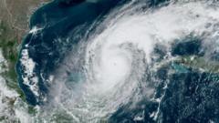
The Department of Defense has decided to continue providing essential satellite data needed for monitoring hurricanes through the end of July, responding to concerns from scientists and forecasters about the risks posed by the cessation of this data.
Temporary Reprieve for Satellite Data Critical to Hurricane Forecasting

Temporary Reprieve for Satellite Data Critical to Hurricane Forecasting
The U.S. Department of Defense extends the availability of crucial satellite data for hurricane forecasting until July 31, easing concerns among meteorologists and climate scientists.
The Department of Defense (DoD) announced on Monday that it would temporarily allow the continued availability of vital satellite data, which is crucial for monitoring hurricane activity. This extension goes until July 31, pushing back an earlier deadline of June 30. The National Oceanic and Atmospheric Administration (NOAA) had previously stated that data from three key satellites, jointly operated by NOAA and the DoD, would no longer be accessible, citing “recent service changes” but failing to provide a comprehensive explanation for the withdrawal.
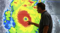
In a follow-up announcement, NOAA attributed the data’s removal to a “significant cybersecurity risk.” This decision to extend the data’s availability was made after a NASA scientist requested it. Many meteorologists and scientists expressed confusion and concern about the initial plan to cut off these data sources, pointing out that such a move would negatively impact the accuracy of hurricane forecasts, ultimately increasing risks to lives and properties across the United States and beyond.
Michael Lowry, a hurricane expert who has previously worked at the National Hurricane Center and FEMA, commented on the government forecasters' surprise regarding the DoD's abrupt decision. He stated, “The extension of this crucial data through July by direct NASA order speaks to how blindsided government forecasters were.” He also noted that the delay does not reach the peak months of hurricane season, which traditionally occur in August through October.
The implications of the satellite data's discontinuation extend beyond hurricane forecasting; it is also vital for researchers analyzing changes in sea ice in the Arctic and Antarctic regions since the 1970s. According to Dr. Sharon Stammerjohn, a senior research associate at the University of Colorado Boulder, “Without that record, especially for the Antarctic, we wouldn’t be able to observe these changes that are so critical to our global climate.” She emphasized that while awareness of hurricanes is widespread, the issues surrounding polar sea ice are less known to the general public.
Alternative satellite products from global agencies like the European Space Agency and the Japan Aerospace Exploration Agency may temporarily bridge the data gap, though challenges may arise from variations in sensor calibration and data resolution. The scenario highlights the intricate relationship between satellite data access and global climate monitoring.