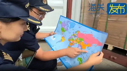
Chinese customs officers in eastern Shandong province have seized 60,000 maps that 'mislabelled' the self-governed island of Taiwan, which Beijing claims as part of its territory. The maps, authorities said, also 'omitted important islands' in the South China Sea, where Beijing's claims overlap with those of its neighbours, including the Philippines and Vietnam.
The 'problematic' maps, meant for export, cannot be sold because they 'endanger national unity, sovereignty and territorial integrity' of China, authorities declared. Maps are a sensitive topic for China and its rivals for reefs, islands and outcrops in the South China Sea.
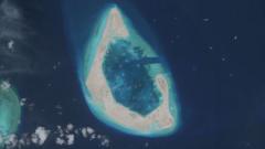
China Customs also noted that the maps did not contain the nine-dash line, which demarcates Beijing's territorial claims over nearly the entire South China Sea. The line comprises nine dashes that extend hundreds of miles south and east from Hainan province.
Additionally, the confiscated maps failed to mark the maritime boundary between China and Japan. While authorities did not specify the exact nature of the mislabeling of 'Taiwan province', Beijing considers the self-ruled island part of its territory and has not ruled out the use of force to assert its claims.
Tensions in the South China Sea have recently escalated, particularly highlighted by a spat involving Chinese and Philippine vessels, with Manila accusing China's ship of aggressive actions.
The Philippines and Vietnam are also particularly sensitive to the portrayal of the South China Sea on maps. Notably, a recent Barbie movie was banned in Vietnam and censored in the Philippines over its depiction of the contentious maritime region.
This recent seizure is not unprecedented; Chinese customs frequently confiscate maps deemed 'problematic'. For instance, earlier this year, 143 nautical charts containing 'obvious errors' in national borders were seized in Qingdao, and last August, maps with inaccuracies regarding Tibetan borders were taken in Hebei.