In brief
The 2026 El Niño is setting new records in central‑Pacific sea‑surface temperatures, surpassing the 2015‑16 event. Concurrent ocean warming from climate change intensifies the anomaly, producing unprecedented warmth and increasing global temperatures. Scientists warn that the heat released by El Niño will drive more extreme weather and threaten food security across affected regions. Although climate change is not proven to make El Niño events stronger, the combined effects are likely to make 2026 one of the warmest years on record.
El Niño is intensifying ahead of its expected peak in December, with scientists reporting the strongest central‑Pacific sea‑surface temperatures on record since 2008.
The Australian Bureau of Meteorology said the average weekly temperatures in the key observing region exceeded the former high set by the 2015‑16 El Niño, the most powerful event in modern history.
Sea‑surface temperatures above 30 °C, never before recorded in this part of the tropical Pacific, are now common across large swaths of the basin. Record anomalies and deep‑water warming are also being measured.
While El Niño is a natural climatic rhythm occurring every 2–7 years, the Pacific Ocean is already warming due to human‑induced climate change, which can mask the extra heating during an El Niño. By applying a Relative Ocean El Niño Index (RONI) that removes the background warming, forecasters can compare the 2026 event more clearly with past super events.
According to Dr Zeke Hausfather of Berkeley Earth, “We are witnessing an El Niño that is unprecedented in the historical record.”
Strong El Niño in a warmer world
Warming in the Pacific now extends well beyond the traditional monitoring zone. Comparison of 2026 with previous super events shows a much wider spread of heat, reaching into the Gulf of Mexico.
WMO scientists say there is no evidence that climate change is making El Niño events stronger or more frequent, but the interaction of the phenomenon with warming seas produces higher global temperatures.
No two El Niño events are exactly alike
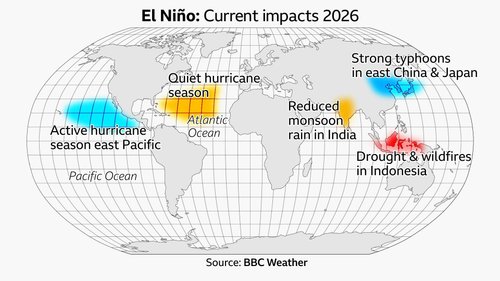
Impacts vary by region and event, although previous super El Niños have shared certain patterns. The 1997‑98 event caused severe drought in Southeast Asia and widespread floods in East Africa, and 2015‑16 produced drought and wildfires in Southeast Asia and a humanitarian crisis in Southern Africa.
These events also ushered in the warmest years on record. The 2026 El Niño is expected to push global temperatures higher, creating a clear risk of extremes, especially in the food‑security‑sensitive areas of East Africa and the Asia‑Pacific.
Forecasts from the European Centre for Medium‑Range Weather Forecasts and the United States National Oceanic and Atmospheric Administration predict a peak in December. This timing aligns with the historical pattern of El Niño’s maximum influence.